2023 The slow road
Returning back home from the South of France, avoiding motorways.
For a lot of people in the North of Europe, summer vacation meant heading South, towards the more sunny places.
For my parents (Dirk's), it was a yearly tradition to go camping in the south of France. 2 Days on the route Nationale in our Citroen 2 CV. As from the seventies, the motorway was completed and the entire 1200km trip could be done in a single day.
Ever since, most of the time when we travelled to the south, the main goal was being at the final destination as fast as possible. When we travelled by motorbike, we sometimes would take the National roads to avoid paying toll, but still the main purpose was getting there.
For a change, we decided to return back home taking the much smaller departmental and local roads and to make this more a sightseeing trip. It was just wonderfull.
Video on DILISTUFF YouTube channel

The Esterel massif

When we returned from Corsica, we stayed a couple of days with our friends in Saint-Raphael.
A nice cycle tour to discover the Massif de l'Esterel is to start from Saint Raphael and follow the coast up to Mandelieu La-Napoule. To return, follow the walking/bicycle tracks of the Parc Naturel departmental de l'Esterel.
More info : Website Esterel-Cote d'Azur


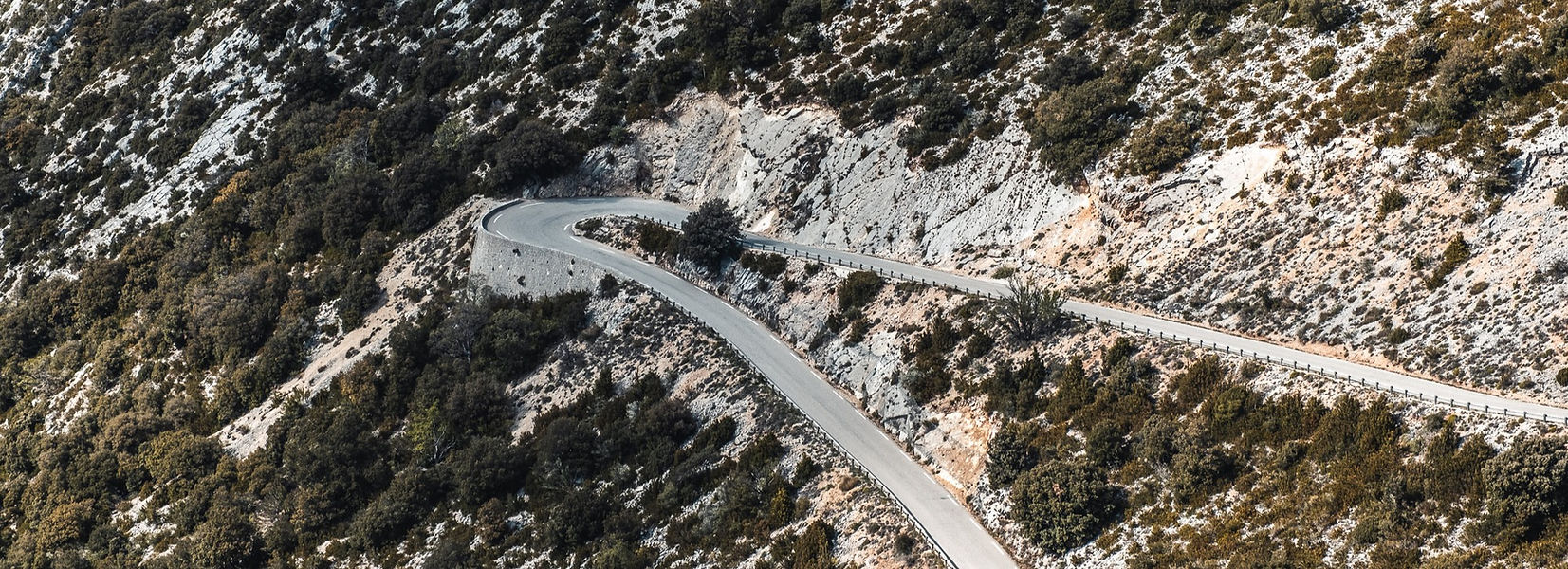
Etappe 1 : Gorges du Verdon

First stop on the way home was the area around the Gorges du Verdon.
The Verdon Canyon is about 25 km long and runs between Castellane and Moustiers-Sainte-Marie. At certain points, the canyon is about 700 meters deep. At the end of the canyon, the river flows in to the artificial Lake of Sainte-Croix.
Some years ago, we had already done the circuit around the canyon by car and by motorbike. This time, our Pendix Santos bikes were having the honour. As usual, we are always (Linda) or nearly always (Dirk) setting the support level on ECO, so it was still a decent workout.


Returning from the circuit around the canyon, you are passing the cute village Aiguines. Here, you find a lot of artisan shops and the one we can recommend is Creations Biala, a woodturner just below the village at the D19.


Another item on our wishlist was going in to the canyon with a kayak. We booked a hotel close to the Lac de Sainte-Croix and made sure we were at the kayak-rental early in the morning.


Moustiers-Sainte-Marie
While we have been in Moustiers-Sainte-Marie before, when we had dinner in one of the little streets, we decided that this place was just to nice to already leave the next day. As usual, Booking.com gave us an easy solution.


Locals told us the best ice cream of Moustiers is at L'Etoile Givree.


Like most other tourists, we walked up to the 262 steps to the Notre Dame de Beauvoir's chapel but we also continued with a walk around the village through Les Claux. Here, we were again our own.
Map and GPX on the website of Moustiers-Sainte-Marie


Etappe 2 : Sisteron
Second etappe of our way back home was from Moustiers-Sainte-Marie to Sisteron, a little bit less than 100 km driving on departementale roads.
When seeing the dried lavender in the shops in Moustiers, we decided to make a little detour via Valensole, famous for the lavender fields of the Provence. For seeing the blooming fields, you need to visit between mid June up to the end of July. More info on the website : Routes de Lavande
Linda likes the smell of lavender and will sometimes add some lavender oil from this area to the laundry liquid.
Between Valensole and Sisteron, we stopped for lunch in the little village of Les Mees with the rather unusual rock formation rising up 100 meters just behind the village.


Sisteron is situated on the banks of the river Durance and is called the "Gateway to the Provence" because it's in a narrow gap between 2 mountain ranges. The city is best known for it's citadel which dates back to the 12th century.
During the French Revolution, the town was mainly royalist and they let Napoleon cross the river without too much hassle on his way to Paris. The Route Napoleon begins at Golf-Juan where Napoleon disembarked after his escape from Elba. His journey ended 100 days later when he was defeated in the Battle of Waterloo. Oh yes, that's 12 km from where we live.


Usually, we are not the type of tourists who visit museums or anything which forces us to leave our bikes and belongings somewhere unsafe.
Being on a trip by car and bikes changes the concept completely. A new world for us.
The Sisteron citadel is very well restored. When entering, you're told that it will take you 90 minutes for the visit but we've spend about 3 hours.

Activity : Hike the Molard Botanic trail.
It takes you a little less than 2 hours to complete the loop starting from the citycenter.
Fantastic views of the city, citadel and surrounding area.


Do you wonder how we take those photo's of the 2 of us ?
Have a look at the upper left picture, it's with our small Leofoto MT-03 tripod.
TIP : For a quick healthy lunch, go to En Catimimi, rue de Provence 89


TIP : For a very nice dinner, which is still not very expensive, go to l'Oppidum - better to make reservations as it seems to be one of the best places in Sisteron.
Just for you to know : An Oppidum is the name of a citadel in Roman time.


Etappe 3 : The Beaujolais
Etappe 3, about 300 km to Julienas in the Beaujolais. This region is about 50 km's long and goes from just south of Macon towards the north of Lyon. It's mainly rolling hills and the predominant grape for the red wines in the Beaujolais are Gamay grapes. And, who does not know the Beaujolais Nouveau which is released each year on the 3rd Thursday of November.
When cycling north of Julienas or Saint-Amour, we are immediately in the Maconais region with it's famous wines like Pouilly-Fuisse.


TIP : For a nice dinner at a still acceptable price, go to restaurant Le Coq a Julienas in the centre of Julienas.
We took their set "menu de coq" which has a choice out of 2 starters, 2 mains and a list of desserts. It was so difficult to make the choice that on the day after, we decided to go back for the other options.


The Maconnais
Located by the river Saone, Macon has a southern character with its colourful facades. In the center, next to the Place des Herbes is still a Renaissance wooden house which was build around the year 1500. The southern region of Burgundy around Macon is called the Maconnais.


In Leynes, you find several artworks from Ted Nomad but we did not find any info on when or why this happened. Anyhow, it's certainly an eye-catcher when cycling through this little village.


The rock of Solutré
The rock of Solutré is just near the little village of Pouilli-Soluté and Fuisse, 8 km west of Macon.
The rock became famous because President Francois Mitterant walked up the rock every year at pentacost. He started this ritual in 1946 as a promise he made to his brother and some other resistance fighters after the 2nd world war ended. Of course, when he became President of France, this yearly event attracted a lot more attention.


Etappe 4 : The abbey of Cluny
Driving further north, direction Beaune, the following stop was the abbey of Cluny.
Founded in 910, the Benedictine Cluny abbey had an exceptional influence over Europe. Their authority extended over 1100 priories and more than 10.000 monks.


The earliest basilica was the largest in the world until the St Pieter's basilica in Rome was build. During the French Revolution, most of it was destroyed.
As part of the visit, you can watch a 3D movie which gives you a good idea how the abbey was in it's glory days.


After Cluny, we were going to drive home and looking for a place to sleep around Beaune. Linda discovered tiny house "La Cabotte Rouge" on Instagram, still available for one night at a last minute - low season price.


